The contents of this legacy page are no longer maintained nor supported, and are made available only for historical purposes.
Abilene Weather Map (using MRTG data)
Mark Meiss
Indiana University Network Operations Center
Indiana University, Bloomington, IN (IU)
URL:
http://hydra.uits.iu.edu/~abilene/traffic/
| Visualization Thumbnail |
About the Visualization |
|
|
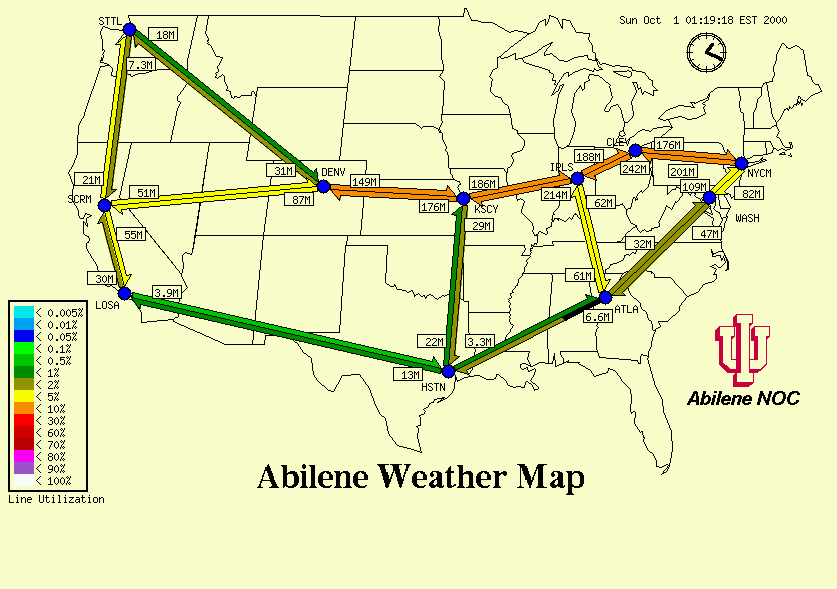
Visualization Techniques:
(Technique1): Configuration file specifies pixel location of
polygonal shapes: circle for each router, bar with half arrowhead for
each link.
|
Key Visualization Mappings:
(Mapping1):
11 core Abilene backbone routers are displayed geographically as
labeled circles:
- STTL = Seattle, WA
- SCRM = Sacramento, CA
- LOSA = Los Angeles, CA
- DENV = Denver, CO
- KSCY = Kansas City, MO
- HSTN = Houston, TX
- IPLS = Indianapolis, IN
- ATLA = Atlanta
- WASH = Washington, D.C.
- NYCM = New York City, NY
- CLEV = Cleveland, OH
(Mapping2): Blue circle indicates router having active links.
Gray circle indicates no active links. Circle is also a hot link to MRTG graphs.
(Mapping3): Link line utilization is colored according to the displayed
key.
(Mapping4): Small box near each link indicates an absolute rate of
traffic in bytes/second.
(Mapping5): Black appearing on any link bar indicates network errors,
and grows logarithmically from base to tip, where the base represents
0.001 percent and the head represents 1 percent errors.
|
Visualization Tools:
(Tool1): Animated Traffic Map CGI scripts
(Tool2): GD Graphics library
(Tool3): MRTG - Multi Router
Traffic Grapher
|
|
| Click Image for Full-Size Visualization
|
Back |